
Analysis of roof water-rich area
According to the detection results of the transient electromagnetic method, Fig. 12 shows the anomaly map of apparent resistivity bedding slices at two depths of 45 m and 60 m from the roof of the working face. From the diagram, it can be seen that 45 m above the roof of Coal Seam 3: in the track groove pile number 1090 ~ 1140 m extended to the working face 60 m, the track groove pile number 1250 ~ 1290 m extended to the working face 50 m, and the track groove pile number 1320 ~ 1350 m extended to the working face 20 m. The apparent resistivity in the abnormal area was less than 4 Ω·m, and the water content of the aquifer was relatively strong. 60 m above the roof of the 3 coal seam: the track groove pile number 1100 ~ 11,150 m extended to the working face 70 m, and the belt groove pile number 1200 ~ 11,240 m extended to the working face 70 m. The apparent resistivity in the abnormal area was less than 4 Ω·m, and the water content of the aquifer was relatively strong.
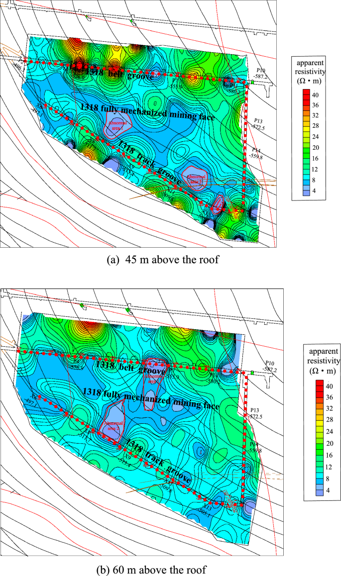
The 1318 Working face roof aquifer apparent resistivity bedding slice diagram and rich water distribution map.
In combination with the results of transient electromagnetic exploration, bedrock exploration results and roof watering during roadway excavation, some abnormal areas were verified. Two abnormal areas were drawn above the roof in the working face, as shown in Fig. 13. Among them, the vertical range of abnormal area 1 is 45–60 m from the roof, with an area of 3334 m2; the vertical range of abnormal area 2 is 30–60 m from the roof, with an area of 2520 m2.
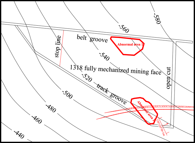
Roof abnormal area of the working face.
According to the analysis of the high-density electrical method results, Fig. 14 shows the high-density electrical method of the geophysical exploration method to detect the working face roof 30 m and 40 m resistivity three-dimensional bedding slice anomaly map. Comparing the 30 m bedding slice above the roof with the 40 m bedding slice above the roof, it can be seen that the resistivity of the bedding slice 30 m above the roof was the lowest, the resistivity of the abnormal area was less than 2 Ω·m, and the water content of the aquifer was relatively strong.
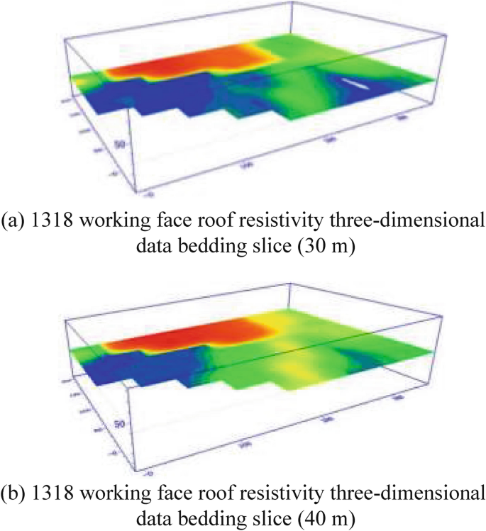
Three-dimensional bedding slice data of the 1318 working face roof resistivity.
Combined with the structural distribution characteristics and hydrogeological conditions of the working face and the results of advanced exploration and drainage in the process of roadway excavation, the water-rich condition of the sandstone aquifer on the roof of the working face is inferred and explained (see Fig. 15). A total of 1 abnormal area was explained in the whole area, with a total area of approximately 3306 m2.
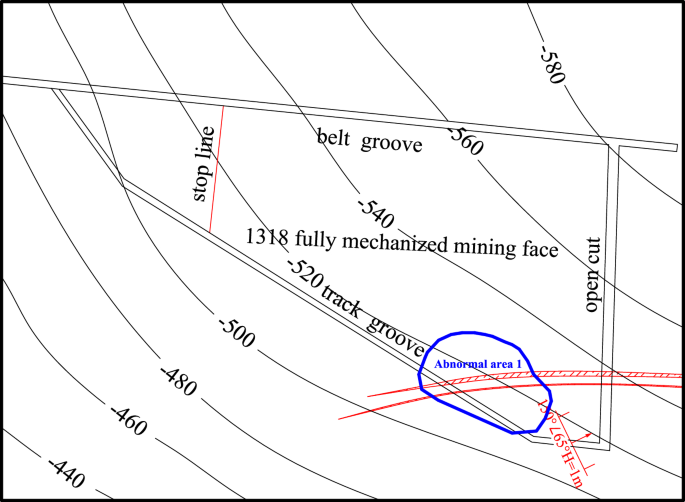
Water-rich distribution of the roof sandstone aquifer in the 1318 working face.
Based on the above geophysical exploration results, two abnormal areas were found in the whole area. The vertical range of abnormal area 1 was 45–60 m from the roof, with an area of 3334 m2. The vertical range of abnormal area 2 was 30–60 m from the roof, with an area of approximately 2913 m2. The water-bearing condition of the roof aquifer of the coal seam in Working Face 1318 was clarified during this survey, and the water-bearing property of the roof aquifer was relatively weak.
Bedrock thickness and structure analysis
Combined with the drilling results, some (TC1-1, TC2-1) drill hole columnar sections were drawn through comprehensive analysis. According to the analysis in Fig. 16, it was concluded that the types of bedrock in the range of the 1318 working face are mainly medium sandstone, fine sandstone, siltstone, coarse sandstone, gravelly medium sandstone and gravelly coarse sandstone, mainly medium sandstone. The cumulative thickness of medium sandstone accounted for approximately 89% of the detected bedrock thickness. Except for the fact that the thickness of fine sandstone at the direct roof of the coal seam was 4.65 m, the average thickness of the other types of rock strata was relatively small, approximately 1 m, which can be regarded as the interlayer of medium sandstone.
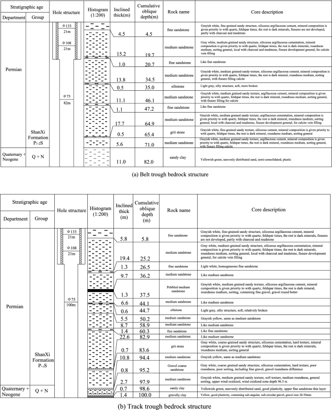
Typical borehole histogram.
According to the drilling data, the bedrock thickness stereogram was drawn after analysis, as shown in Fig. 17. The bedrock thickness in the range of the 1318 working face increases gradually from southwest to northeast. The thinnest part was located at the intersection of the stopping line and track groove, and the thickness was approximately 60 m. The thickest part was located at the intersection of the cut-hole and belt groove, and the thickness was approximately 180 m. The bedrock thickness in the mining range of the whole 1318 working face was greater than the 55 m…
Read More: Study of the mining and aquifer interactions in complex geological conditions